No one knows what will happen.
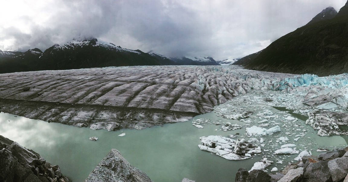
As early as Sunday, the glacier-fed reservoir known as Suicide Basin will overtop the vast wall of ice and stone holding it in place in a crooked arm of the Mendenhall Glacier.
The water will start flowing slowly, in a trickle over the icy dam. That trickle will erode the dam, allowing a stream to escape. That stream will cut further into the dam, allowing a river to flow. That river will gash the dam like a ceaseless knife, releasing a torrent.
And then what?
“Nobody really knows,” said U.S. Geological Survey hydrologist Jamie Pierce.
Pierce has been studying (and been frustrated by) the Suicide Basin reservoir for years. Now he and others (experts from the National Weather Service and University of Alaska) are awaiting something new. For eight summers in a row, Suicide Basin has collected, then released, pulses of rainwater and glacial melt through a system of drainage channels beneath the Mendenhall Glacier. Water collects in the basin, a dead-end branch of the valley that contains the glacier, until its weight (and the warmth of summer) melts the ice that holds it in place.
In the last week of June, a spectacular event disrupted that cycle: A chunk of ice a fifth of a mile wide splashed into the basin with a titanic roar, sending shards flying and leaving on-site scientists agog.
At the time, it was thought that the ice would break the seal on the basin, triggering the annual glacial flood known as a jökulhlaup. The Weather Service even issued a flood watch as a precaution.
Instead, the level of water within the basin kept rising. Instead of breaking the seal, the calving ice seems to have strengthened the dam holding the water in place. That has allowed more water to collect in the basin, which now holds about as much as it did in 2016, a year of record floods along the Mendenhall River.
While it is possible that the traditional channels could open again, Suicide Basin’s reservoir is now only 8-12 feet from the top of its icy dam, and a breach is imminent.
“Essentially, we’re looking at a near-record event again,” said National Weather Service hydrologist Aaron Jacobs.
Significant flooding is only a possibility, not a certainty. Floods along the Mendenhall River depend upon the level of water within the lake and river, not just the amount of water entering it from Suicide Basin. Cool, dry weather tends to lower the amount of water within the lake and river system.
Furthermore, said Christian Kienholz, a scientist studying the basin, there’s no way to tell how the water will behave when it leaves the basin. He and Pierce each suspect the water will flow down the eastern border between the glacier and its boundary rocks. At some point, probably within 1,000 feet, it will encounter a crevasse and start flowing into the glacier.
If the glacier acts as a damper, it might release the water slowly, over days or weeks, and water levels on the lake and river will stay relatively low. A faster release increases the danger of flooding.
Past releases beneath the glacier have resulted in the river cresting within three days.
“What I would expect is that will be a fairly slow process,” Kienholz said.
“It’s going to around, through, under, down,” Pierce said of the water when it enters the glacier.
It’s possible the water, when loosed, could cause the face of the glacier to calve into Mendenhall Lake, though that’s seen as relatively unlikely. Also unlikely is the possibility that the water from Suicide Basin would simply flow along the glacial boundary and cascade in a waterfall into the lake.
But no one has seen this kind of thing at Suicide Basin before, and there’s no certainty what will happen. If there is any danger, Jacobs said there will be plenty of warning.
While loose ice has repeatedly broken a gauge measuring the water within the basin, there are other instruments and a remote camera keeping an eye on things.
“It’s OK. It probably will be a big event, but there’s going to be plenty of time to get things off of the ground and get things out of the way,” Jacobs said.
In the meantime, Kienholz and Pierce are planning a trip to see the basin in person, hopefully before it releases its water.
“From a scientific perspective, Suicide Basin is such a great place to examine these processes,” Kienholz said. “We can learn about these processes and try to better understand them.”
• Contact reporter James Brooks at jbrooks@juneauempire.com or 523-2258.

