
In 1894 a Canadian surveyor named William Ogilvie hiked to the top of Mount McGinnis to photograph the peaks protruding through the Juneau Icefield. His assignment was to help determine the boundary between Canada and the United States in order to clarify a treaty signed by Russia and Great Britain in 1825. While atop the mountain, he turned his camera toward the ocean and made one of the first photos of Mendenhall Valley.
The glacier extended well into the valley at that time, revealing concentric rows of moraines. No lake existed yet. Little could the famous Canadian know how different the valley would look and how the melting glacier would threaten homeowners 130 years later.
The remarkably clear image on a 4×6-inch glass plate negative would join 7,000 other photo plates to make a zigzag summit-to-summit map of the international border shared by Alaska and British Columbia in Canada.

This photo was taken from the top of Mount McGinnis in 1894 as part of a series of photos used to triangulate summit peaks for establishing the border between Alaska and Canada. Canadian surveyor William Ogilvie turned his glass plate negative camera toward the ocean and toward Mendenhall Valley to give a view of the large fan-shape of glacier, rows of moraines and no lake. (Courtesy Jim Geraghty and National Snow and Ice Data Center)
The Southeast Alaska boundary with Canada originated as an uncertain line created by an 1825 treaty between Russia and Great Britain during the early fur trading days. The two countries had tacitly agreed to allow the British Hudson’s Bay Company to retain fur trading rights with Alaska Native people of continental coastal Alaska. The Russians had claimed the outer waters and islands for sea otter hunting by using skilled but poorly treated Unangax and Alutiiq/Sugpiaq hunters.
As the densely-furred marine otters were hunted to near extinction, Russia’s interest waned. The Alaska colony was too far away from Russian headquarters in St. Petersburg and the fur operation was becoming economically unfeasible.
Thus, the two European countries divvied up the remaining spoils, ignoring the Alaska Native people whose land they had appropriated without permission, and drafted a boundary agreement. In essence, the Russians got the archipelago islands and the British got the mainland. However, the deal was not so clear.
The border was fuzzy in Southeast Alaska due to a lack of geographic understanding: the treaty said the boundary should run parallel to the sinuous line of the coast and no more than 10 marine leagues — about 30 miles — from the ocean. It was a border of words only.

A present-day map displayed in the Mendenhall Glacier pavilion shows the zigzag border which runs from summit-to-summit as agreed in the original 1825 treaty between Russia and Great Britain. Canada and the United States surveyed the line in the late 1800s and again after a boundary tribunal in 1903 gave the entire coast to Alaska. (U.S. Forest Service map)
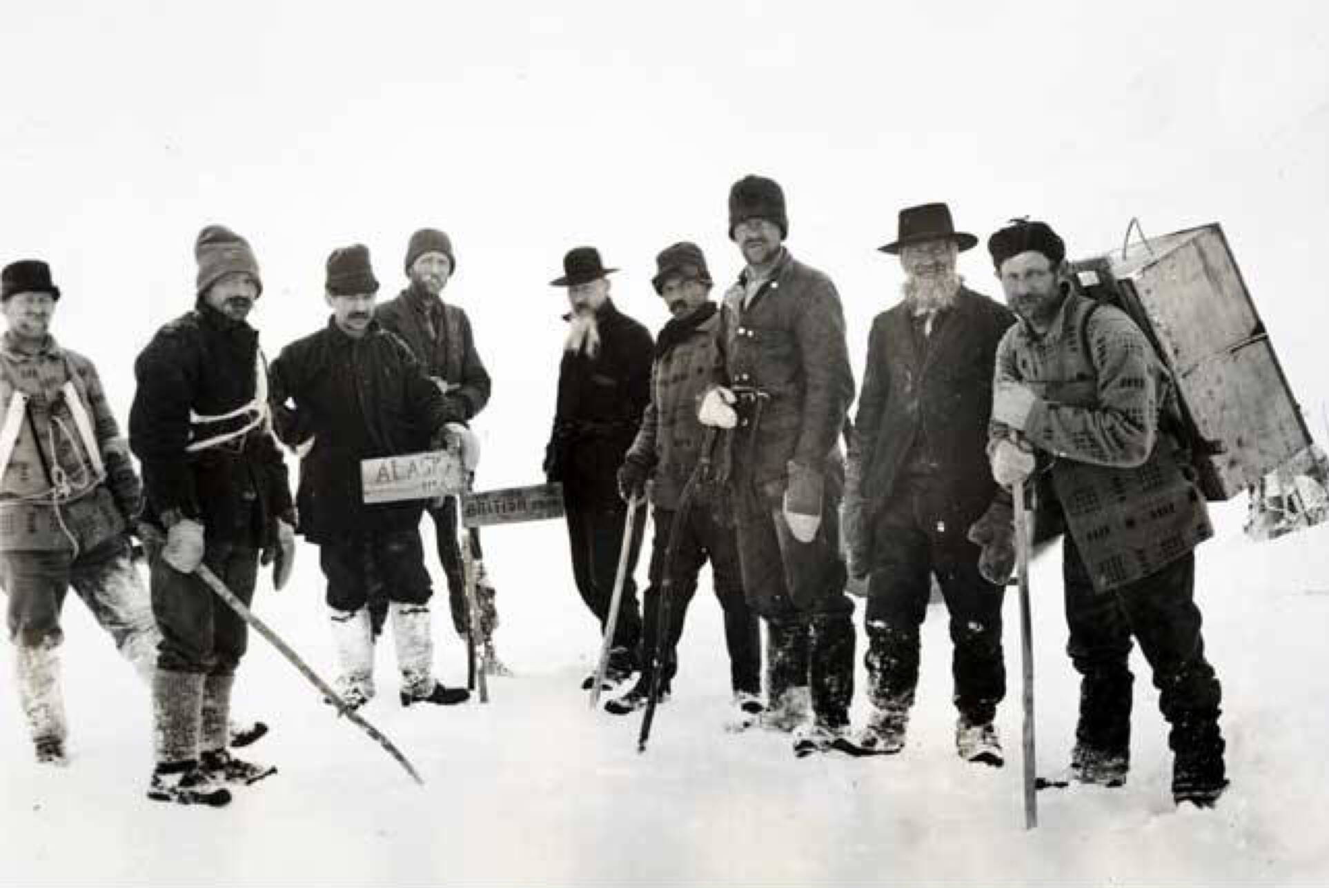
After the U.S. 1867 purchase of Alaska from Russia, the inherited treaty needed clarification. In the 1890s, Canada and the U.S. jointly decided to delineate the border more precisely. Canadians would survey the land portion and Americans would survey the rivers. The countries would create maps based on the surveys. Leading the agency for American surveys was a man named Thomas Corwin Mendenhall, superintendent of the U.S. Coast and Geodetic Survey. His name is ubiquitous in Juneau today.
Due to the rugged terrain there were places impossible to reach with survey equipment. A plan was devised to use photos to triangulate locations. That process provided the 1894 Mendenhall Valley photo that intrigues people today.
At first — and seen from sea level by the early Russian-British mariners — it is likely treaty makers didn’t realize the extent of the icefield that blocked the imagined demarcation line. They presumed row after row of mountains rimmed the land. Instead they found a jumble of peaks, valleys, glaciers and plateaus of snowy ice. That made following the dictate of the treaty to make the border parallel to the windings of the coast and from peak to peak more challenging than initially thought.

A photo showing 8,584-foot Devils Paw from the Taku River inlet south of Juneau. The solitary rock spike called Michael’s Sword is visible to the left. Devils Paw is designated as Boundary Peak 93 on the map of approximately 185 border peaks from Hyder, Alaska, and Stewart, British Columbia, north to Mount Saint Elias at the 141st meridian. (Photo courtesy of Cathy Connor)
A few problems arose with interpreting the 1825 treaty language: definition of the coastline, questions about what constitutes the ocean and a misunderstanding about the disorganized arrangement of mountains.
While the 1890s survey data were collected and being reviewed, the boundary issue erupted onto the world stage by the discovery of gold in Canada’s Klondike that set off a global rush in 1897 with key access points being at the head of Lynn Canal.
To resolve treaty concerns an international Alaskan Boundary Tribunal was convened in London in September of 1903 at the behest of President Theodore Roosevelt. The tribunal was composed of six members: three were American, two were Canadian and one British Lord Alverstone (Canada was officially a Crown possession).
The tribunal tackled seven irksome questions. The most challenging issue in northern Southeast Alaska concerned which country controlled access at the head of Lynn Canal. They were to determine if the coastline included “inlets, bays, ports, havens and waters of the ocean,” in Question 5. Would the boundary run around the heads of these waters or across them?
The Canadians argued that the “ocean” by their definition ended at Berners Bay where Lynn Canal narrowed to three miles wide. According to their position, Canada, therefore, would own northern ports, such as the notorious gold rush port of Skagway, because the land belonged to Canada. The Americans said otherwise.
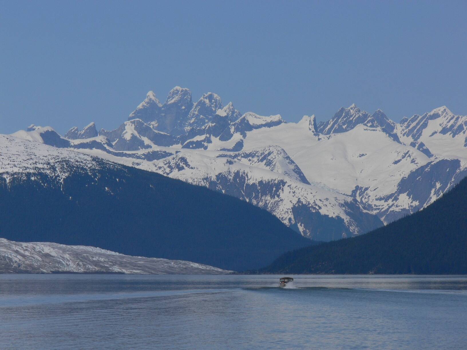
A view of a boat passing near Taku Glacier with Devils Paw mountain in the distance. (Photo courtesy of Steve Gilbertson)
In his final decision regarding the language of the 1825 Treaty, Lord Alverstone, the Chief Lord of Justice for England, voted with the Americans. He affirmed that “the line of demarcation shall follow the summits of the mountains parallel to the coast,” and that the border would run around the waters of Lynn Canal, not across the narrowed portion.
While he and the Americans approved, the two miffed Canadians refused to sign the final document. They had lost marine access for their country approximately north of Prince Rupert.
The tribunal also settled concerns about the southern Alaska-B.C. border. There were contentious discussions about waterways and islands which resulted in a split of ownership through the middle of Portland Canal, south of Ketchikan. Today, the U.S. port city of Hyder is isolated from much of America’s resources. However, a friendly relationship has developed with the adjacent Canadian town of Stewart, British Columbia which has a road connecting to continental highways. Some Alaskans suggest restoring an Alaska Marine Highway System ferry to Hyder to give access to Canada and the Lower 48 by road.

In some locations a 20-foot wide border line was cut through vegetation. Here the late Vern Gilbertson is seen in about 1999 near the Taku River border cut in the background. (Photo courtesy of Steve Gilbertson)
While most boundary peaks are hidden from view, for Juneauites the distinctive local summit is visible by sea and air at the head of Taku River. Devils Paw, also known as Boundary Peak 93, “is a magnificent peak towering fully a thousand feet higher than any peak in the vicinity, its altitude being 8,584 feet. It is formed by three separate peaks of which the middle one is the highest, and from the arrangement of these peaks as viewed from the westward the name ‘Devils Paw’ seems very appropriate,” reported Canadian surveyor W.L. Ratz in the tribunal proceedings.
While the tribunal resolved issues, further surveying was needed to refine the maps. Some boundary markers were placed at accessible locations. One of those sites attracted then-Alaska Governor Clark and Secretary of Interior Walter Fisher to the White Pass and Yukon Route Railway summit where the men posed for a photo beside a tall obelisk. Their steps were easy compared to the many men who hiked along the border and figured out where to build that monument.
• Contact Laurie Craig at laurie.craig@juneauempire.com.

Seven volumes of transcripts document discussions from the 1903 Alaskan Boundary Tribunal. Canada, U.S. and Great Britain convened to clarify language from an 1825 boundary treaty. These books are in the reference archives at the Alaska State Library, Archives and Museum in downtown Juneau. A large map atlas accompanies the report. (Laurie Craig / Juneau Empire)

Secretary of Interior Walter Fisher and Alaska Territory Governor Walter Eli Clark (1909-1913) stand beside the boundary monument at White Pass in this undated photo taken near the White Pass and Yukon Route Railway that connects Skagway with Whitehorse, Yukon Territory, Canada. (ASL-P75-317)
