

Newly installed equipment is contributing to improved monitoring and forecasting of Suicide Basin’s glacial outburst flooding, according to expert researchers holding a town hall at the University of Alaska Southeast on Monday.
However, researchers emphasize much remains uncertain when it comes to forecasting the jökulhlaup (glacial outburst flood).
Suicide Basin is a side basin of the Mendenhall Glacier above Juneau. Since 2011, the basin has released glacier lake outburst floods that cause inundation along Mendenhall Lake and Mendenhall River multiple times each year, including record flooding last August that damaged or destroyed dozens of homes.
A jökulhlaup occurs when a lake fed by glacial meltwater breaches its dam and drains rapidly. The lake water levels must reach a critical point where it causes its ice dam to float, overtops its dam, or carves large meltwater channels beneath the glacier ice that allow for drainage.
It’s notable that jökulhlaups may occur with somewhat regular periodicity, but others drain without warning.
For example, Juneau has recorded the Mendenhall Glacier’s jökulhlaup happening in July, but also as late as October. Last year’s flood released more than 13 billion gallons of water, causing Mendenhall River to reach a record-breaking 15 feet on Aug. 5.
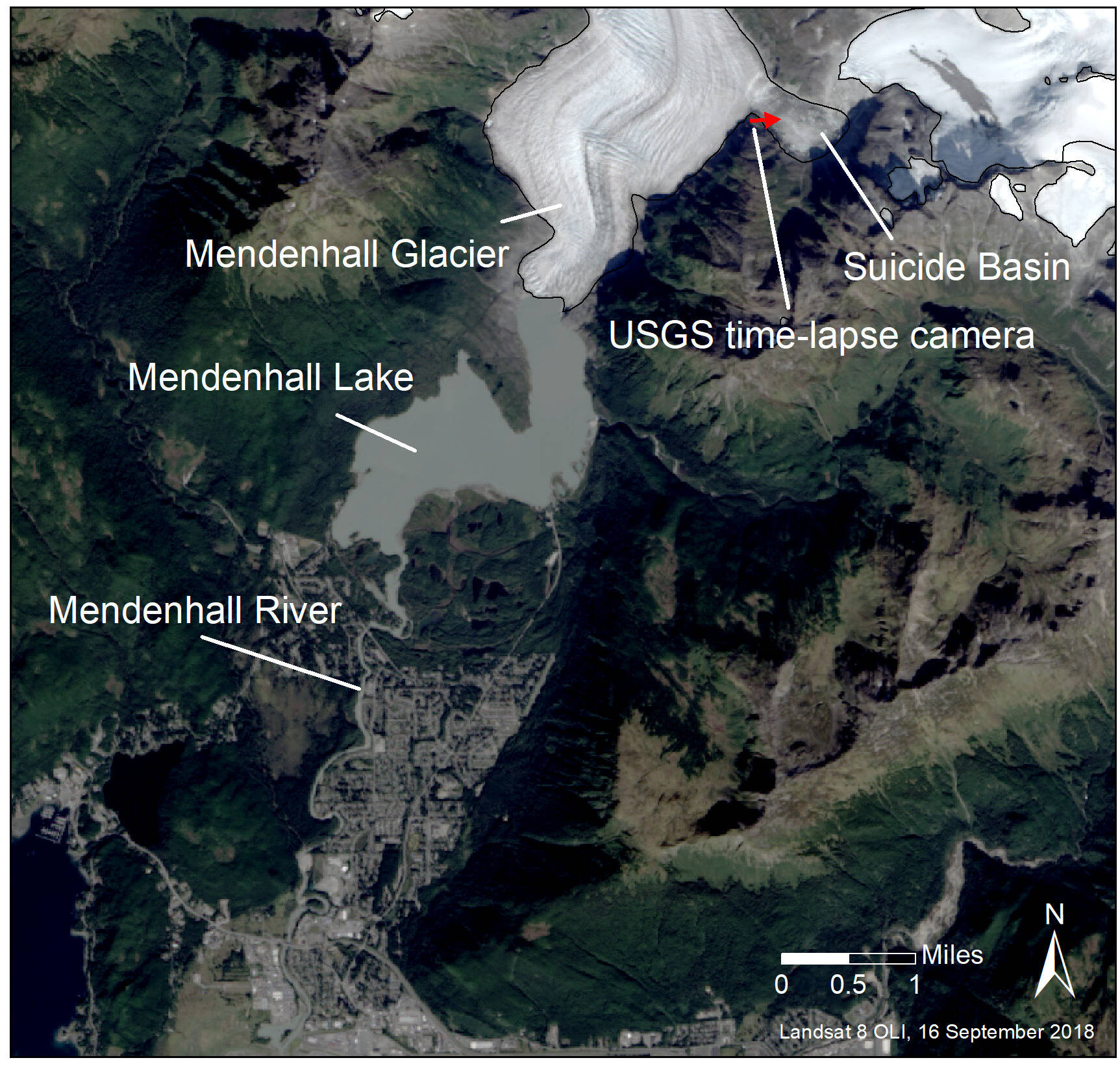
A map of Suicide Basin in relation to the Mendenhall Glacier and the Mendenhall Valley. (Photo from National Weather Service Juneau website)
The U.S. Geological Survey visited the basin on May 24, and was able to install a second camera and new temperature, precipitation and water level equipment.
“It’s not the easiest place to get in and out of,” said Jamie Pierce, a USGS hydrologic technician. “We had to use some creativity to do it. Luckily the USGS has been doing this for a while; we’ve monitored other glacial lake outburst floods around the state. We’ve developed some techniques at this survey that are good.”
Pierce said the USGS’ role is to measure water in Suicide Basin and provide background information for the National Weather Service Juneau and UAS to utilize.
Data access continues to be worked on and the new equipment will provide increased situational awareness. A graph showing the current pool height of Suicide Basin will be available soon. These values come primarily from a pressure transducer, secondarily from a laser detection system, and can be estimated using camera imagery if needed.
Using the latest imagery, the water level in the basin is about 100 feet lower than in 2023. Images from the entire 2024 season can be viewed at www.weather.gov/ajk/suicideBasinScaleImageViewer.
Once the second camera is fully up and running, an alternate basin image from a different view will be available, allowing a wide-angle view of the base of the glacier and a stitched image.
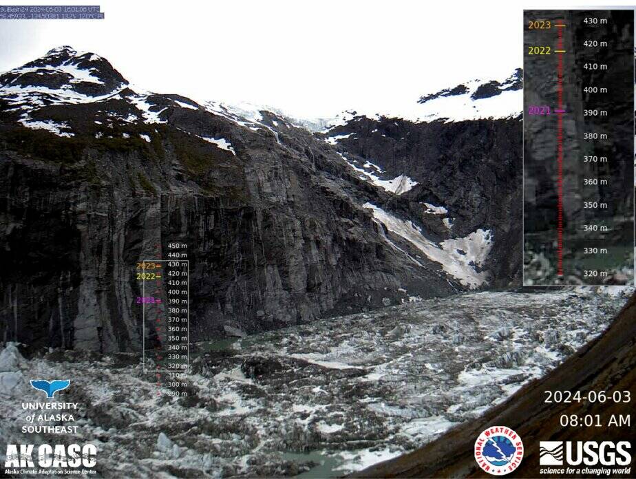
An image from Suicide Basin is updated at daily to sub-daily intervals (see time-stamp bottom right). The camera is placed at the basin entrance and faces northeast, into the basin. (Screenshot from National Weather Service Juneau website)
USGS will transmit data from the basin every 30 minutes this summer — last year data was transmitted every hour.
“May not sound like a big deal,” Pierce said. “But we want it because we all know the anxiety when the basin’s filling and not releasing. We want to know the second it starts and the second it drops.”
Along with the improved USGS monitoring equipment, NWS’ updates include river forecasts, inundation maps on the new web page, and an improved Mendenhall GLOF monitoring page.
Aaron Jacobs, senior hydrologist for the National Weather Service Juneau said when the start of an event is identified, NWS forecasts will be the worst-case scenario for a full release of water in the basin. This is for emergency planning purposes. Since the flood reached a record-high of 15 feet last year, the current plan models 16 feet to be the worst-case scenario. The volume of water in the basin will be calculated from previous research and real-time water levels from the USGS.
But not every year is expected to reach those high levels. One out of six large glacial outburst floods over the past eight years was a near-full basin release of water, according to Jacobs. There are many variable factors and still much to understand about forecasting the size of a partial release.
“Last year was something we didn’t see before,” Jacobs said. “Unfortunately, there’s not really a confident way to say the size of this release. Is it going to be a full release? Only half? Three quarters, or a certain percentage? That is what we’re trying to get.”
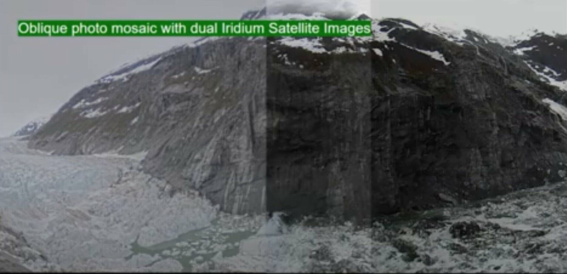
A fully stitched image of the one above will soon include a fuller view of the dam and will be made available to the public this summer. The imagery will be updated hourly. (Screenshot from “Building a Weather-Ready Nation” presentation)
When asked if Juneau experts have contacted other researchers on glacial outburst floods for advice, Jacobs said their group studying the glacial outburst flood in Juneau is likely the most researched of its kind in the world.
Eran Hood, an environmental science professor at UAS has been conducting the university’s drone mapping program to conduct orthoimages of the entire basin, computer-generated images of an aerial photograph in which distortions caused by terrain relief and camera tilts have been removed. It combines the image characteristics of a photograph with the geometric qualities of a map.
Hood said this is helpful because they could take the difference of the pre-flood and post-flood images of Suicide Basin to calculate its approximate volume.
“One of the things that was very kind of stunning when you went up there last year is how far down the whole thing had collapsed after the flood had drained,” Hood said. “That was something that we hadn’t seen before. Now we know sort of more what the bottom of the basin is and so for any given water level that we have with the sensors that Jamie put in, the weather service can calculate the volume of water that’s being stored at that time.”
UAS will continue its drone mapping program this year.
“Competing processes drive outburst flood dynamics,” Hood said. “People always ask, well is it going to get bigger over time? Or is it going to get smaller over time? To answer that question accurately we need to be able to quantify how these competing processes are interacting with each other as we move forward.”
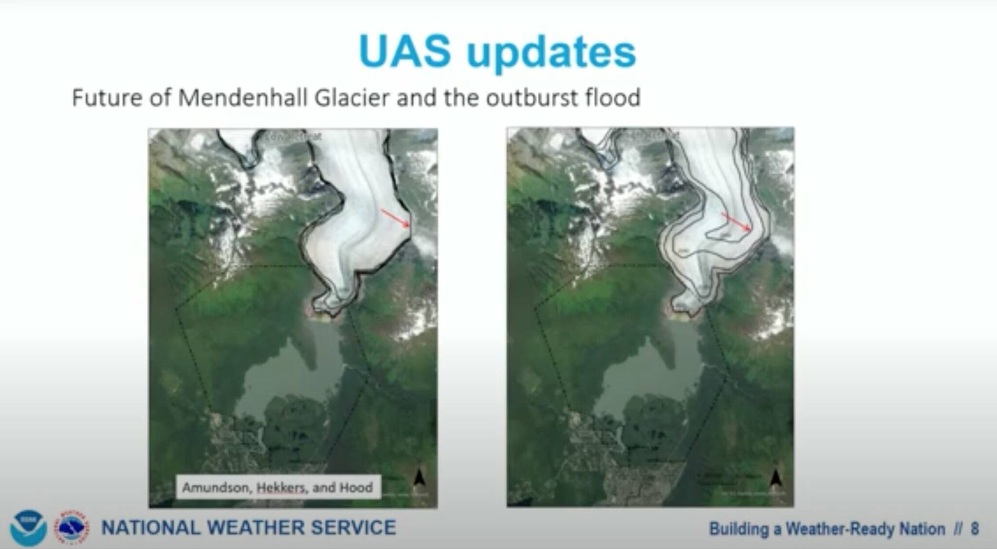
Left: Low-retreat rates scenario. Right: High-retreat rates scenario. (Screenshot from “Building a Weather-Ready Nation” presentation)
Examples of competing processes include the basin being full of icebergs and its changing dam. As icebergs melt, a bigger flood is more likely, but at the same time, the dam itself, the Mendenhall Glacier, is thinning at five to six meters per year. Every year the dam becomes lower and thinner, which means the flood should get smaller in the future, according to Hood.
“We’re also trying to start a project where we’re kind of modeling this going forward on more decadal timescales,” Hood said. “The basic thing that we need to think about is, well, what’s going to happen with the glacier in the future? How rapidly is the glacier retreating? And so, we did a modeling exercise for the Forest Service in thinking about their planning at the Visitor Center. We came up with some different scenarios rates at which the Mendenhall Glacier will retreat in the future.
“If you look at 2050, it’s pulled back, there’s not even going to be a dam there,” Hood said. “So that can’t be a flood anymore. Eventually, the flood will disappear when the glacier retreats back far enough.”
Still, other basins could emerge as new threats. Researchers are monitoring potential new basins and their risks.
Tom Mattice, emergency manager for the City and Borough of Juneau, said CBJ will be soon launching Civic Ready, and an Integrated Public Alert and Warning System. IPAWS is a federal system where the city can locally trigger the Emergency Alert System and send messages directly to cell phones. Civic Ready will be available to subscribe to through the CBJ website to allow phone calls and text messages regarding emergencies.
With these new systems, the city will be able to notify people about flood evacuation by specific neighborhoods.
Mattice said anyone living left of Riverside Drive needs a safety plan in place, including emergency kits and a safe place to stay for the night. He said now is a good time as any to begin preparing. CBJ will issue a press release once the notification systems are available to sign up for.
• Contact Jasz Garrett at jasz.garrett@juneauempire.com or (907) 723-9356.
