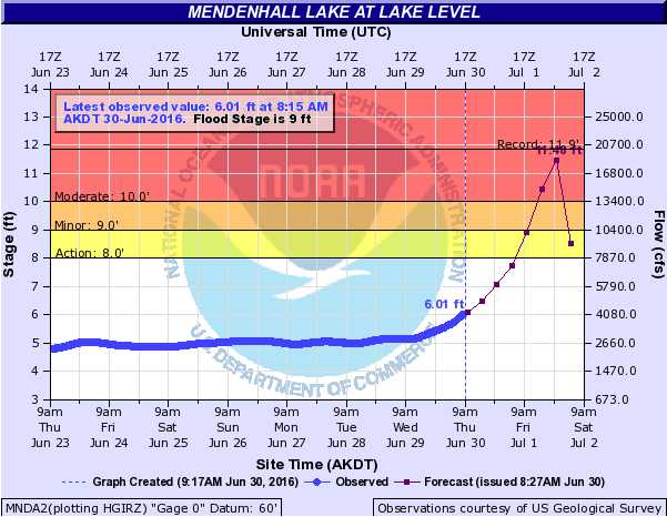
The first jökulhlaup of the season has begun, and according to a National Weather Service hydrograph, this year’s glacial outburst flood may be bigger than any from 2015.
Suicide Basin, a depression above the Mendenhall Lake filled with rain and melted glacier, began draining into the Mendenhall Lake and river Thursday morning, according to the city.
Though it’s tough to predict how much water the basin is releasing and when the water level will peak, a National Weather Service hydrograph forecasts that the lake will reach 11.4 feet. Flood stage is around 9 feet, and the historic high — set during a Jökulhlaup in 2014 — is 11.85 feet.
The water level of Mendenhall Lake is at about 6 feet currently, and the hydrograph indicates that the water level will crest sometime between Friday and Saturday.
The city has issued a public service announcement urging residents in the affected area, primarily those who live along the river, to “monitor the situation and be prepared to take appropriate precautions.”
Once the lake reaches about 9 feet, water begins to cover West Glacier Spur Road and the Mendenhall Lake Campground. At 9.4 feet, View Drive will start to flood. And at 10.4 feet, some homes along View Drive could have as much as 3 feet of water in their yards. Some homes in the area will experience “significant flooding” and View Drive will be impassible at 10.9 feet, according to the National Weather Service.
Editor’s note: This is a developing story. Check back later for updates.
•Contact reporter Sam DeGrave at 523-2279 or sam.degrave@juneauempire.com.

