A storm that knocked out power to portions of Southcentral Alaska with hurricane-force winds will arrive in the Juneau area late Wednesday and early today.
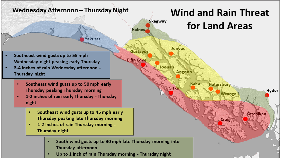
The National Weather Service office in Juneau on Wednesday said in a special weather statement that “a potent weather system currently over the west-central Gulf will move into the eastern Gulf Wednesday night and across the panhandle today. Potential impacts from this system include significant disruption to marine and aviation operations as well as power outages.”
The storm has already affected Southcentral Alaska, where gusts neared 100 mph, and area electric companies reported scattered outages.
Several cargo aircraft were diverted from Anchorage International Airport to the airport in Fairbanks.
More than two inches of rain fell on Seward in less than 12 hours overnight Tuesday into Wednesday, with minor flooding reported.
Juneau meteorologist David Levin said by phone that Juneau and Southeast Alaska shouldn’t expect conditions that severe.
“We’re going to see mainly a quick burst of heavy rain tomorrow morning,” he said Wednesday by phone, “then the winds are going to come up.”
Peak wind gusts in the Juneau area are expected to reach 45 mph, with windier weather at higher elevations.
As to rainfall, “we’re expecting between 1-2 inches in the Juneau area,” Levin said. “Basically from late tonight into tomorrow morning is when the heaviest rain will fall.”
The most severe conditions are expected offshore and along the outer coast. Yakutat is expected to receive 3-4 inches of rainfall, and Sitka should expect slightly less.
Rough sea conditions were already being reported Wednesday by automated buoys. At 8 a.m., a buoy just southeast of Seward reported seas exceeding 20 feet. Another at the mouth of Prince William Sound recorded waves of more than 15 feet.
In the wake of those waves, the state ferry Tustumena canceled a scheduled trip to Seldovia and revised its sailings to Kodiak and Alaska Peninsula ports. The ferry Kennicott, bound from Juneau to Southcentral Alaska, will stay in Yakutat until 10 a.m. Thursday to ride out the worst of the storm.
Today is the autumnal equinox, marking the official beginning of fall, Juneau’s rainiest and stormiest season.
So far this year, the capital city has already seen wetter-than-normal conditions. Through Wednesday morning, Juneau had seen 44.71 inches of precipitation (rain and melted snow) at the airport, the city’s official measuring location.
The normal mark for this point in the year is just 38.74 inches, but this year’s above-normal rain- and snowfall pales in comparison to last year’s record-breaking wet, when 59.26 inches of precipitation had been recorded by this point in the year.
• Contact reporter James Brooks at 523-2258 or james.k.brooks@juneauempire.com.

