
James and Bill Montivér had just finished boxing up their home on a steep road in Ketchikan, a fishing community turned cruise ship stop in southeast Alaska, when they heard a screech like a jet engine over the sounds of pouring rain.
Bill, who was scrubbing the kitchen cabinets, screamed and dropped to the floor as the house shook. In the next room, James was thrown from the couch into the ceiling, before crashing back down. The impact dislocated his shoulder; Bill fell into the basement as the kitchen collapsed from the force of the landslide.
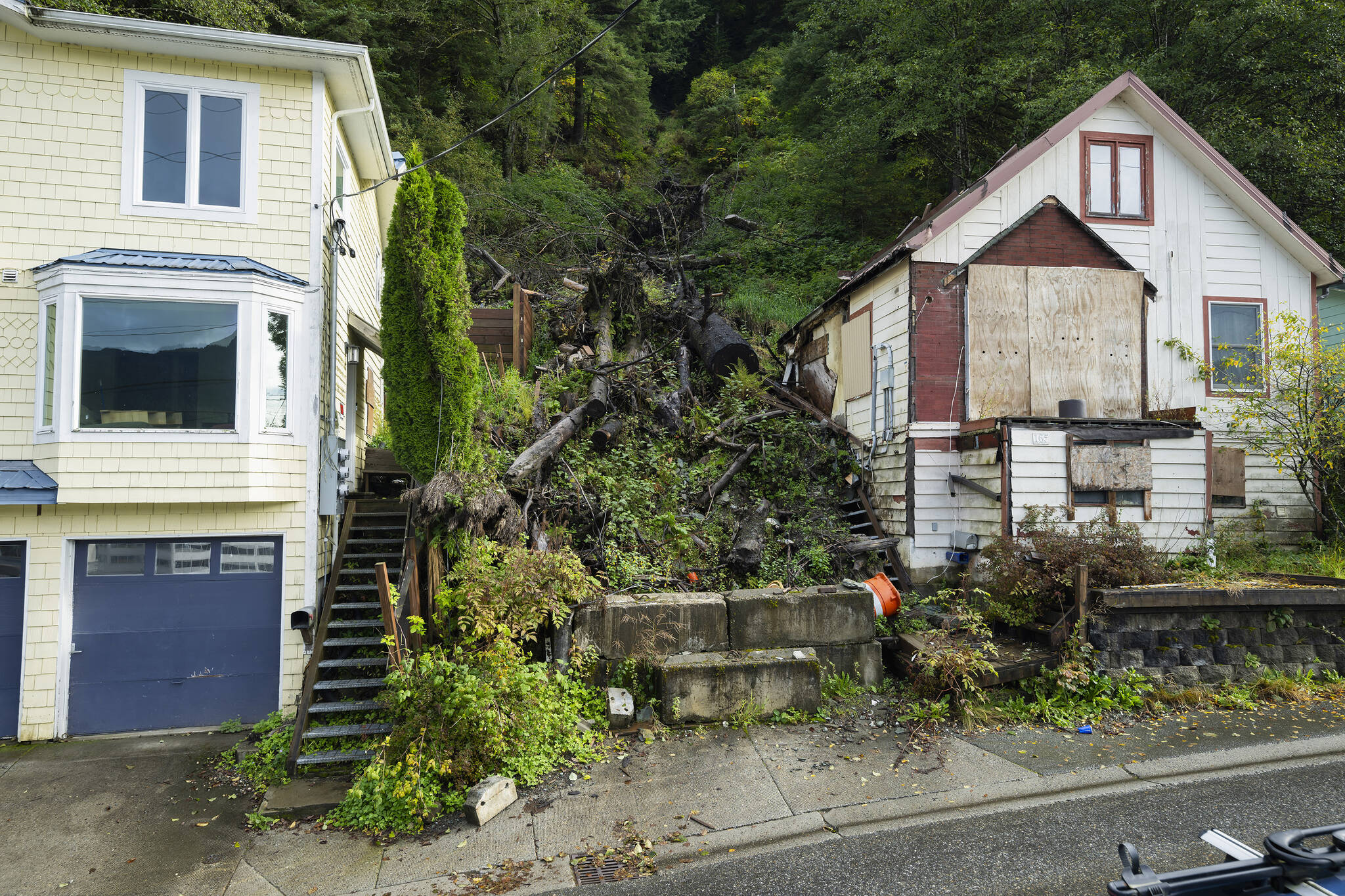
Both men survived the wall of mud, rocks and trees the size of shipping containers that exploded into the almost 100-year-old home they’d planned to sell three days later. But one block away, a maintenance worker clearing storm water drains died when the earth slammed his truck off the road. Up the hill, a clean brown chute like a ski slope, cloaked on both sides by hemlock and spruce was left behind.

James Montiver, right, and his husband, Bill, with their dogs, Alani and Cassie, on the site of their home, which was destroyed by an August landslide, in Ketchikan on Oct. 9, 2024. Deadly landslides are increasing around the world, but in parts of Alaska, maps of the hazards remain controversial. (Christopher Miller/The New York Times)
Over the past century, landslides in the state have periodically taken out power lines or disrupted roads. But until about a decade ago, they were rarely known to rip apart homes, and they were not commonly claiming lives in southeast Alaska. From 2015 to this summer, four deadly landslides struck some of the largest towns in the sparsely populated region — Sitka, Haines, Wrangell and then Ketchikan, in August — killing a dozen residents.
The region’s challenging landscape means housing is in short supply while emergency managers, forecasters and other experts encourage more towns to adopt hazard maps that show what land might be susceptible to sliding. The knowledge might save lives, but it could also limit what pockets of development are still possible.
Scientists are finding out some people don’t want it. Residents of Juneau, the state capital and the region’s biggest city at just over 31,000 people, convinced assembly members in the city to vote against adopting the maps, claiming they could lower their property values. “You have something that for many people is their biggest investment,” said Shawn Eisele, a Juneau resident, referring to homeowners in his neighborhood. “If you create a landslide zone, that’s a huge impact on those people.”
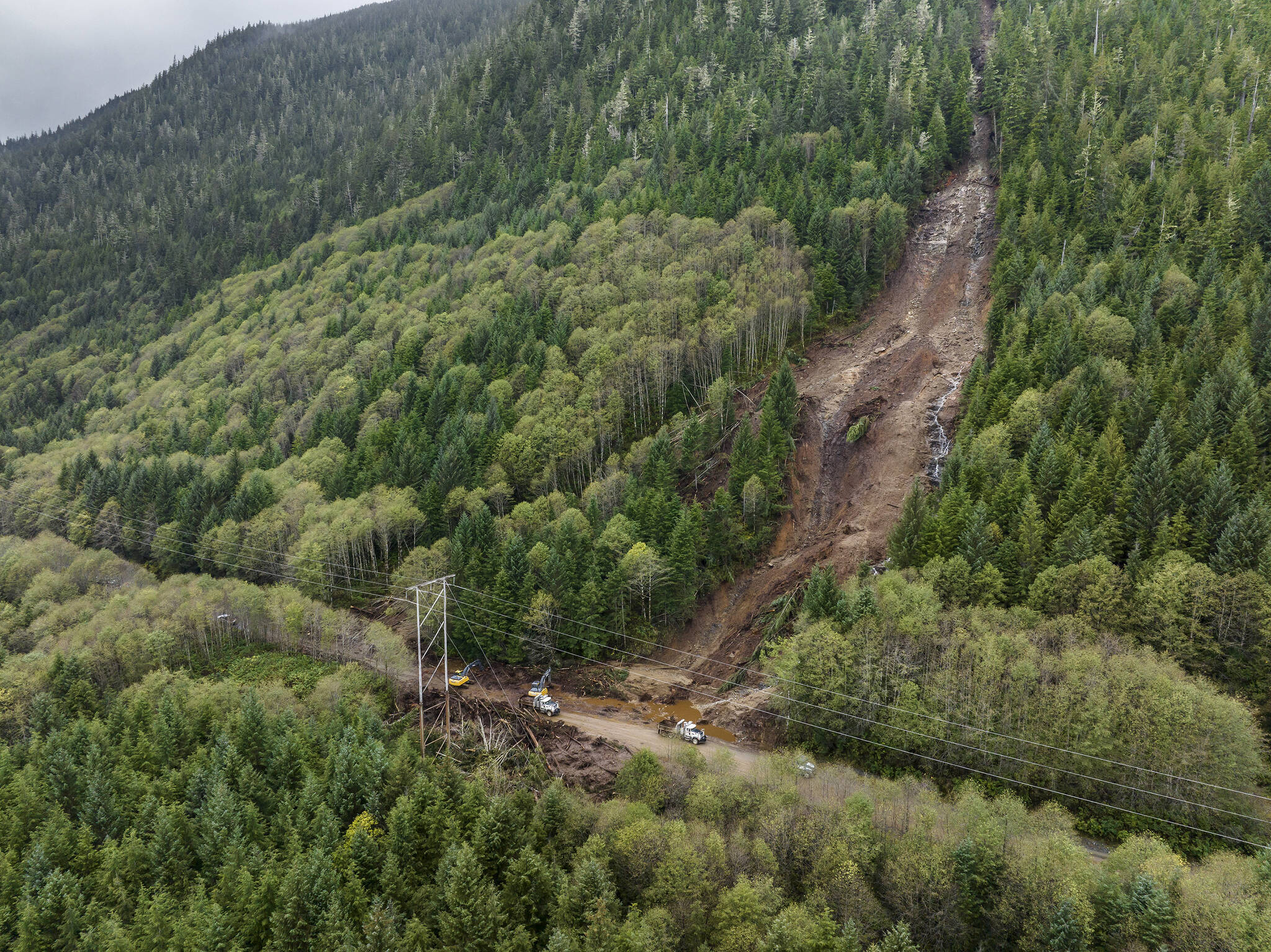
Maintenance workers clear debris from an Oct. 6 landslide that blocked Revilla Road in Ketchikan on Oct. 9, 2024. Deadly landslides are increasing around the world, but in parts of Alaska, maps of the hazards remain controversial. (Christopher Miller/The New York Times)
Yet as emissions from burning fossil fuels ratchet up the Earth’s temperature, pushing more moisture into the atmosphere, intense rainfall events are becoming more common. Southeast Alaska has seen increasingly short and heavy bursts of rain from atmospheric rivers, carpets of moisture that sweep in from the gulf before pounding into the mountains. Precipitation is the hazard’s biggest trigger: More rain means more landslides.
Roughly a month after the Ketchikan slide, Hurricane Helene caused hundreds of landslides in southern Appalachia; more than 600 have affected rivers or critical infrastructure. “We can say for certain that we’re seeing more landslides occurring because of the effects of climate change,” said Dave Petley, a landslide expert at the University of Hull in England.
Since January, more than 4,000 people have been killed in landslides around the world.
Towns in southeast Alaska are particularly vulnerable. Residents have settled wherever they could, perched on hillsides between trees and sea, mounted precariously above ports. And when towns need to build more, they often extend up the mountain.
“Our No. 1 issue is to make sure people have enough housing, so the idea of kicking people out anywhere is really challenging,” said Christine Woll, an assembly member in Juneau who voted against adopting the maps after her constituents complained.

Kanaan Bausler, who works for the local power company, digs a trench for cables to supply a lysimeter, a device for measuring the amount of water transported through soil, on the side of Mount Roberts on Sept. 26, 2024. Deadly landslides are increasing around the world, but in parts of Alaska, maps of the hazards remain controversial. (Christopher Miller/The New York Times)
The conversation around landslides began in 2015, a few days before Christine McGraw was scheduled to move into her newly built home at the edge of Sitka’s Harbor Mountain, when a torrent of earth poured down 1,200 feet from the peak. The local building inspector and two brothers doing a last-minute paint job were inside Ms. McGraw’s house when the landslide hit. All three died. It took eight days to recover their bodies.
“You can’t prevent a landslide, and a house can be rebuilt, but the lives lost you can’t get back,” Ms. McGraw said. “What I lost is nothing compared to what those families lost.”
She was denied coverage under her homeowners insurance. Ms. McGraw then sued the developer who sold her the property and recouped enough to rebuild. Her new home is on Japonski Island, connected by a bridge to central Sitka and about the farthest she could get from the mountains in the area. She now works as a real estate agent and recommends her clients use what landslide susceptibility maps are available to learn more about the risks.
On a recent overcast morning, Jacqueline Foss drove her silver truck up the mountainside that claimed Ms. McGraw’s house almost a decade ago. Ms. Foss, a soil scientist with the United States Forest Service, was studying the persistently damp dirt beneath the 16.8 million-acre Tongass National Forest.
Soils in the Tongass, the nation’s largest rainforest, have adapted to extremely wet conditions. They are thin and porous, swiftly filtering water that pools down with gravity to bedrock before slipping on to the waterline. But sometimes rain can get clogged in sheets of soil, such as the ash left by volcanoes, creating a slick lane. Like a layer cake, if it gets slippery enough, gravity can tilt the top layer downward, causing it to slide off.
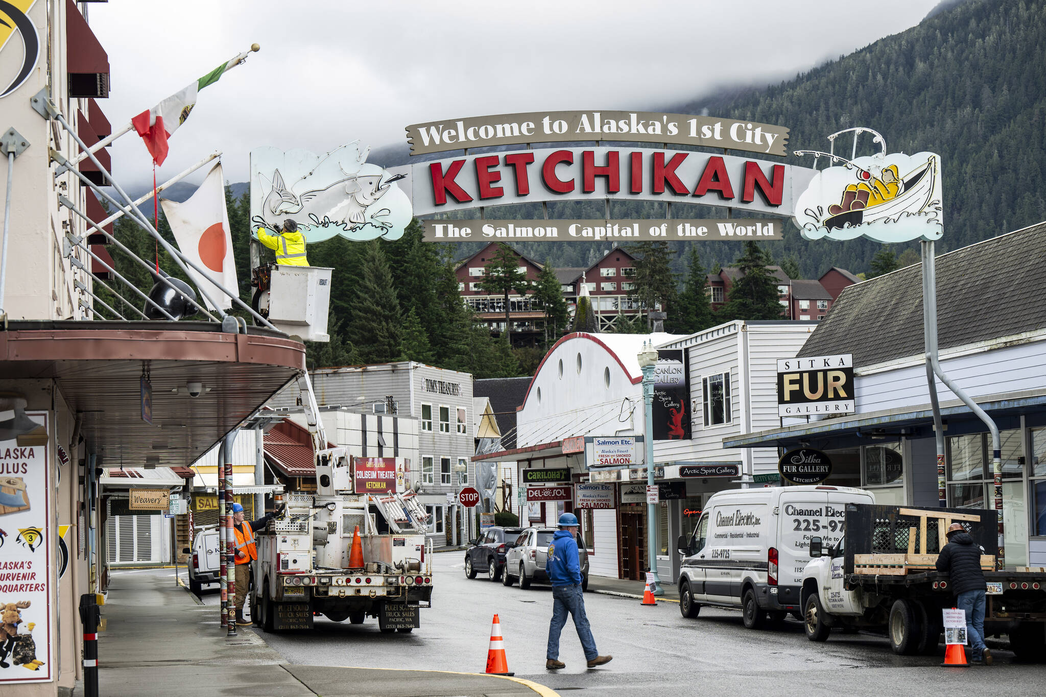
Electricians replace sections of neon tubing on a sign that greets visitors to Ketchikan, a fishing community turned cruise ship stop with a population of 8,000, Oct. 9, 2024. Deadly landslides are increasing around the world, but in parts of Alaska, maps of the hazards remain controversial. (Christopher Miller/The New York Times)
The pandemonium that is a landslide can also be triggered by earthquakes or the weakening of a slope from deforestation or development. Loosened permafrost, rapid snow melt or retreating glaciers can also lead to landslides. But scientists agree that the main catalyst is rain.
Ms. Foss reached a small clearing at the end of a wet, unmarked trail where a crimson rain gauge about six feet tall measured precipitation. About 50 feet away, a pair of gray plastic tubes snaked into the earth, delivering data on soaked soils.
This is the missing piece for forecasters like Aaron Jacobs, the senior service hydrologist and meteorologist for the region’s National Weather Service station in Juneau. He relies on the data to determine whether the soil is wet enough for a forecast amount of rain to potentially trigger a slide. But because the soils here are so varied, and Tongass is so huge, while the data can help inform when a landslide might occur, it’s nearly impossible to figure out where.
After the Sitka landslide, community members, scientists and tribal leaders worked together to develop a simple warning system. It functions like a traffic light, using green, yellow and red to show the forecast for landslide risk depending on current data from the National Weather Service and historical weather data gathered at the local airport.
The dashboard has downsides: It is Sitka-specific, and it has never been tested by a landslide. But Lisa Busch, the former director of a local nonprofit called the Sitka Sound Science Center, said she helped develop the dashboard to keep attention on the risk.
“Honestly, we didn’t think about landslides before 2015,” Ms. Busch said. “Now when it rains hard, everyone’s anxiety goes up.”
Sitka’s renaissance of landslide research bled into Juneau. The gold rush-era downtown, built into the side of Mount Roberts, has dealt with periodic slides for almost a century. While there has not been a fatal one since 1936, residents are worried when Juneau’s turn will come.
“It’s not a matter of if it’s going to happen but when,” said Raymond Paddock III, the environmental coordinator with the Central Council of the Tlingit and Haida Indian Tribes of Alaska.
In 2019, Juneau took a proactive approach, using a federal grant to hire TetraTech, a consulting firm, to update the downtown’s hazard maps with state-of-the-art technology. But last December, Juneau’s town assembly voted against adopting the new maps.
Katie Koester, the city manager for Juneau, who cannot vote in the assembly, said its members made a decision to prioritize personal choice over government regulation. The hazard maps are available on the town’s website, but there are no restrictions around building in a zone identified as high hazard on a landslide map. Ms. Koester said she was not aware of any conversation in the community to change that.
Mr. Jacobs worried that his Weather Service statements about landslide risks associated with severe storms would not be as helpful if residents were not aware of which areas were more dangerous.
“People first need to know, am I in a high-risk area, and if so, when do I need to stay away for the night?” Mr. Jacobs said. In the future, he wanted to see communities end development in high-hazard zones.
While most people assume they would be covered against such a catastrophe by their homeowners insurance, in the United States such policies do not cover “earth movement” like floods, earthquakes or landslides. While separate insurance policies exist for floods and earthquakes, landslide coverage is even harder to afford and nearly impossible to find. Experts say that is largely because the risk is so difficult to predict and the marketplace of people requesting the insurance is so small.
Because of the insurance hurdles with landslides, affected residents say they rarely use the geological definition of the event when applying for coverage, but they’re still often denied.
The Montivérs called what destroyed their home “the event” or “the incident” but their insurance denied any coverage. Unable to sell a home that doesn’t exist, the couple, in their late 60s, still owe $169,000 on their mortgage.
Tommy and Stephen Varela-Kossak bought the three-bedroom house next door to the Montivérs for $425,000 in June. They had made a single mortgage payment before the landslide, but the bank still expects the couple to make 30 years of mortgage payments. They have received a three-month collection pause while they try to appeal their insurance denial, arguing that the Montivérs’ house dislodged their own, not the landslide.
“We did everything right,” Tommy, 27, said. “But our only option might be filing bankruptcy.”
• This article originally appeared in The New York Times.
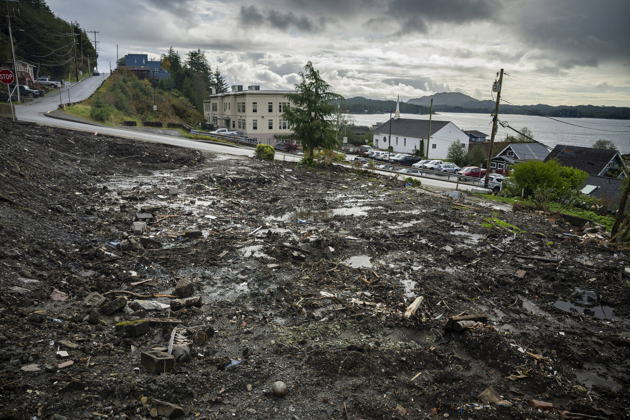
The empty lot with the remains of James and Bill Montivérs’ home in Ketchikan on Oct. 9, 2024. Deadly landslides are increasing around the world, but in parts of Alaska, maps of the hazards remain controversial. (Christopher Miller/The New York Times)
