Generally, there’s a low risk of a large tsunami hitting Juneau.
There aren’t tsunami sirens in town, as City and Borough of Juneau Emergency Programs Manager Tom Mattice explained, because the city doesn’t qualify for a siren system by federal government standards. A new study might force Mattice and the federal government to reexamine that likelihood, though.
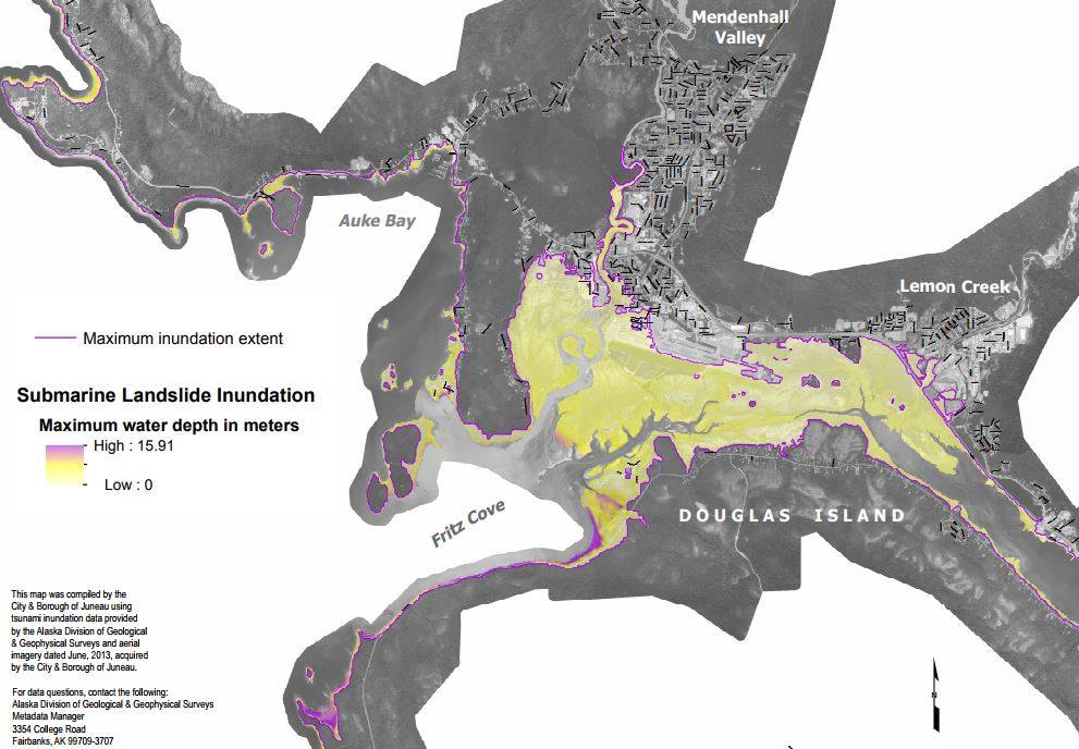
The study, done by the Alaska Division of Geological &Geophysical Surveys, includes a series of maps and hypothetical worst-case scenarios concerning what they call landslide-generated tsunamis, and released their findings last week. These kinds of submarine landslides have not been studied much, but they can be extremely dangerous.
Offshore tsunamis, the ones we hear about the most, are caused by large, sudden movements of the ocean floor and often start out in the ocean. Therefore, tsunami warning systems and evacuation plans can be put into place and people can be warned. With an inshore/landslide-generated tsunami, they can start in a matter of moments.
“When that occurs, there’s no emergency alert system,” Mattice said. “There’s no buoy system. There’s nothing telling us it’s coming.”
It’s difficult to fully comprehend what these tsunamis would look like. Mattice said a major earthquake could cause an underwater landslide (what he calls a “slump”) at locations throughout the area that are prone to this. Mattice said that Juneau, with glacial rebound and steep shorelines, has a couple of areas that are vulnerable. In a release from the CBJ, Mattice said this study helps him and his staff better “understand evacuation areas and response.”
[Expert: Juneau tsunami unlikely]
The main area detailed in the report is at Fritz Cove, where an underwater slump could cause sea levels to raise by 40 or 50 feet. If this happens at low tide, it might not be a terribly destructive event, Mattice said. With Fritz Cove located near the Juneau International Airport, though, an inshore tsunami at high tide could be disastrous.
“A 40-foot run-up on a king tide is gonna take out your airport,” Mattice said.
Other areas in town at risk, according to the report, are Berners Bay, Eagle River, Sheep Creek and South Franklin Street. If a landslide-generated tsunami begins in the Taku Inlet, the report detailed, it could create a rise in sea level of 35-45 feet but would run out of energy as it rebounded down Gastineau Channel and reach downtown in six or seven minutes with a rise in sea level of 6-10 feet.
Mattice posted two maps on the city’s website, one detailing how much water levels could rise from an offshore tsunami and how much they could rise from a submarine landslide. The worst-case scenarios for an offshore tsunami, according to these maps, is up to about 16 feet. The worst-case scenarios for submarine landslides is about 52 feet.
When the largest earthquake in North American history occurred north of Prince William Sound in 1964, the landslide-generated tsunamis caused an estimated 85 of the 106 Alaska deaths, according to findings released in 2016. There was no warning time for these powerful waves.
Preparing for a wave
Joel Curtis, warning coordination meteorologist with the National Weather Service, wanted to stress that this study is looking at the absolute worst-case scenarios.
Following the 1964 earthquake, the tides were 4-6 feet higher than normal in Juneau, the report states. This, Mattice said, is the most likely tsunami scenario for Juneau. A rapidly-rising tide at high tide would still be worth alerting people in town and having them evacuate, but it would be what Mattice called “a non-event” at low tide.
It’s been decades since a 6.0-magnitude earthquake hit Juneau, but it doesn’t hurt to prepare, Mattice said. Like with most disasters, the work is mostly in the preparation. Having a “go-bag” ready at all times is a smart move. This bag would have water, first-aid materials, a flashlight, food, prescriptions and other essential items.
It’s also wise to have an evacuation plan, a meetup point for your family for when you’re in different places and to know which areas of town are the best to go in the case of a rapid rise in sea level.
Once the ground starts shaking, Mattice said, start counting. An earthquake that lasts 20 seconds is likely a 6.0-magnitude quake.
“If the earthquake is 20 seconds or longer or it’s strong enough to knock you down, seek higher ground,” Mattice advises.
Juneau could lose internet access for days after a major quake if internet cables are severed, and banking systems might also not work. Curtis shrugged his shoulders and laughed as he said he usually doesn’t carry cash, so he might not have access to much money in a disaster.
The most important problem, he pointed out, isn’t be related to one’s bank account.
“The real impact here? Food, logistics, coming from Seattle,” Curtis said. “That’ll be the big impact.”
With Juneau so dependent on outside food, residents would have to fend for themselves for a few days. Those with emergency food tucked away would be fine for a while, as well as those who maintain their own personal garden. Mattice joked that he’d go out fishing and try and feed as many people as he could in this scenario, and Curtis met a man recently who said that if his village were cut off from the outside world, he would grab his gun and seek out deer.
“King crab season will be open that week,” Mattice jokes with people. “We’ll work it out.”
• Contact reporter Alex McCarthy at 523-2271 or alex.mccarthy@juneauempire.com.

