This is a developing story.
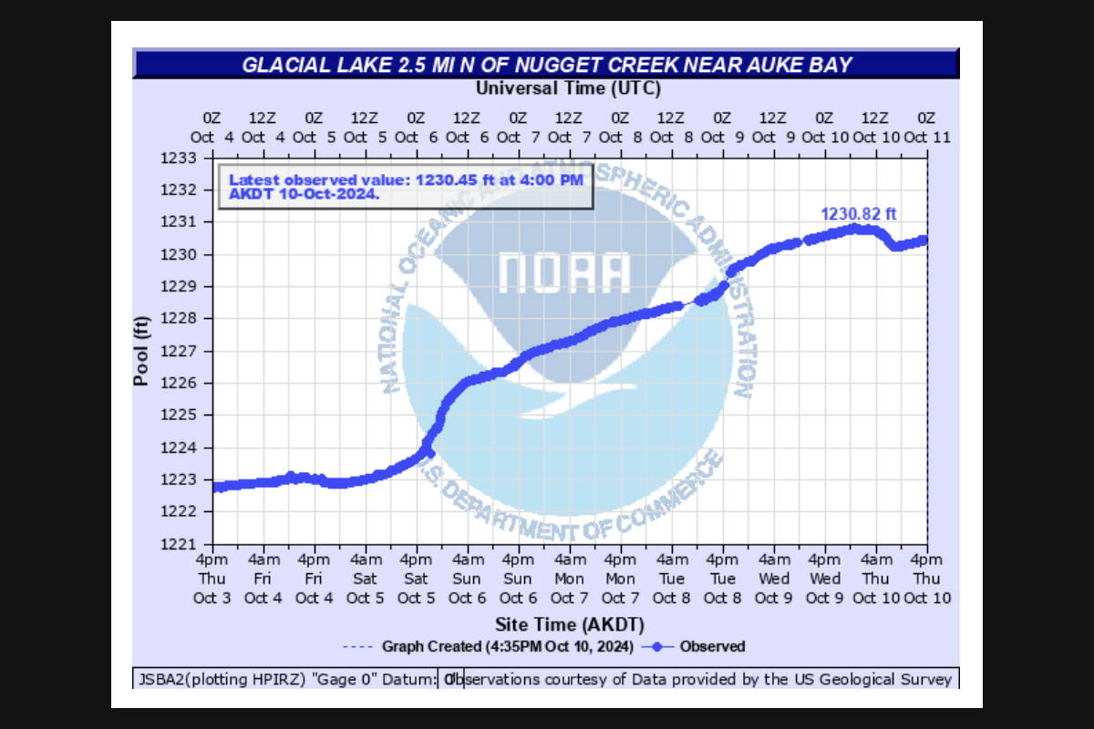
A drop in Suicide Basin’s water level observed Thursday morning appeared short-lived, as the water level was again rising during the afternoon, according to an update published at 5 p.m. Thursday by the National Weather Service Juneau.
The basin is being monitored by NWS Juneau, which in an update at its monitoring website stated a full release of water now would result in the Mendenhall River cresting at about 11 feet — five feet lower than the record flooding that damaged about 300 homes in early August.
If a full release does occur the river would be expected to crest about 12 to 24 hours later, said Erin Brunsen, a NWS Juneau meteorologist.
An 11-foot crest would be considered “moderate flood” stage, according to NWS Juneau data. However, a statement posted by the agency notes officials are still trying to determine if a release is occurring and, if so, how much of the basin may drain.
“(View Drive) will be flooded and impassable with significant flooding to some homes in the area,” a NWS Juneau flood inundation mapping webpage notes. “Locations below Back Loop bridge will see bank erosion along unreinforced river banks along with hazardous navigation from debris in the river. Homes along the river on Meander Way will begin to see flooding of some backyards. Portions of the Dredge Lake Trail System will be impassable. Flood waters start to reach Dredge Lake.”
Most of the damage to homes in the Mendenhall Valley during the August flood after the river surpassed the 15-foot level — the peak of a then-record flood the previous year that damaged or destroyed about 40 homes largely along the bank of the river.
An update issued at 11 a.m. Thursday at the NWS Juneau’s Suicide Basin monitoring website stated “the latest data from the laser pool elevation gauge is indicating a drop in water level within Suicide Basin.”
“This could be an indication that a basin release has started,” a special weather statement issued by NWS Juneau added.
The current water level in the basin is about 1,230 feet, roughly equal to conditions that existed in early July, according to the monitoring website.
Glacier outburst floods from Suicide Basin have occurred annually since 2011 and more than one release in a year is not uncommon, Aaron Jacobs, a hydrologist for the NWS Juneau, told the Juneau Assembly at an Oct. 3 meeting. However, he told members there has never been a second major flood from the basin and there is virtually no chance of a major flood this month since colder weather means the basin is filling at a much slower rate than it did this summer.
• Contact Mark Sabbatini at mark.sabbatini@juneauempire.com or (907) 957-2306.

