A weekend storm with gale-force winds and significant rain is expected to increase the risk of hazards along the Mendenhall River after record flooding last weekend, and may mean rough conditions for boaters participating in the Golden North Salmon Derby, according to the National Weather Service.
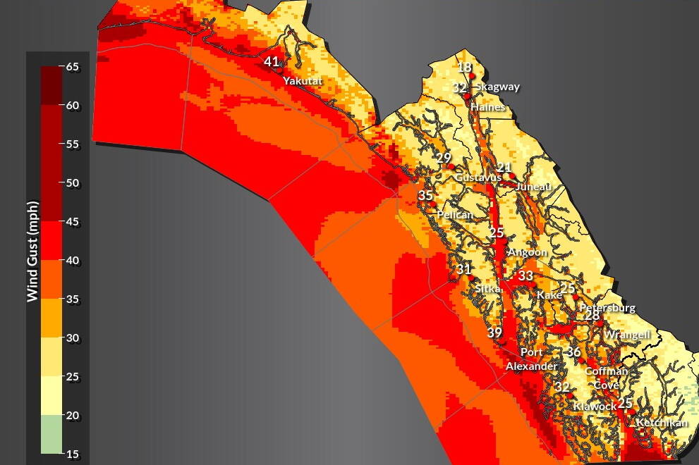
The peak of the storm is expected Saturday with the strongest winds hitting at sea, said Caleb Cravens, a meteorologist with NWS Juneau. The current forecast calls for winds of 20 to 30 knots through Saturday afternoon, and possibly reaching 35 knots by Sunday in southern Lynn Canal. The moderate to heavy rain could bring a total accumulation of two to three inches.
“It’s going to be a nasty weekend to be out there and it can get pretty pretty rough,” he said Thursday. “So we would definitely want to encourage the mariners to pay close attention to the forecast and not get out into anything that those boats can’t handle.”
Caution is also being urged for people along the Mendenhall River, where record flooding from Suicide Basin last Saturday decimated the riverbanks, said Katie Koester, city’s public works director and incident commander for recovery efforts related to the flood.
“We want people to stay away from the riverbanks over the weekend with this event,” she said.
The worst conditions are expected in the outer and southern portions of the Southeast Alaska panhandle, according to a weather service bulletin. Yakutat, Sitka, Wrangell and Ketchikan are among the communities expected to see the most rainfall.
Winds gusting to 35 mph on land in Juneau is the primary concern along the river, said Aaron Jacobs, a NWS Juneau hydrologist. Homes, trees, fuel tanks and other large items were washed away, and he said more objects may end up in the river during the storm because of the still unstable soil.
“Those trees that are unstable from being undermined and not falling into the river yet could be a threat for residents and folks around the Mendenhall River,” he said.
Koester said other debris from the storm, such as wreckage from homes, generally is at the high-water mark from last weekend’s flooding and thus shouldn’t be at risk of being washed away. She said the Coast Guard and other officials have also been removing hazardous items such as loose fuel tanks from the affected area.
The river is expected to rise one to two feet due to the rain, which is far below the flood levels seen last weekend when the river crested at nearly 15 feet, Jacobs said.
The storm is expected to arrive during the last weekend before school starts again and Cravens said the wet weather is another indicator fall is approaching.
“This is kind of our first big storm of the season,” he said. “Think of it as like the systems that we get in the fall usually, this is kind of the same category as those.”
• Contact Mark Sabbatini at mark.sabbatini@juneauempire.com or (907) 957-2306.

